
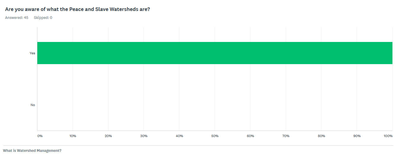
Integrated Watershed Management Plan
Integrated Watershed Management Plan
The Integrated Watershed Management Plan of the Peace and Slave Watersheds balances and supports our social, environmental and economic objectives.
The purpose of this plan is to address effective and sustainable management and use of the water resources. It will also address the maintenance of other benefits provided by the ecological functioning of the watershed. Ensuring that cumulative effects are understood and communicated among all users of the watershed is necessary to improve decision-making about human activity in the watershed. Creation and implementation of this plan will support the achievement of Water for Life’s three main goals of: safe, secure drinking water; healthy aquatic ecosystems; and reliable, quality water supplies for a sustainable economy.
A big thank-you to all the members of the Water Quality, Availability and Consumptive Use working group, the Wetlands and Wetlands Loss working group, the Peace River Flow Regime working group and the Non-saline Groundwater working group!
Below are an interview on Q99 about the Integrated Watershed Management Plan and a narrated slideshow of the Integrated Watershed Management Plan.
A brief introduction to the DRAFT Integrated Watershed Management Plan for the Peace and Slave Watersheds of Alberta.


Working Group Reports
A big thanks to all of the working group members for their input, work, time and problem solving efforts. These reports are the work of the respective working groups and were submitted to the Mighty Peace Waterhshed Alliance’s Board of Directors for review. The Board of Directors received and reviewed these reports with their broad sector perspectives and used these reports to inform the DRAFT Integrated Watershed Management Plan for the Peace and Slave Watershed.
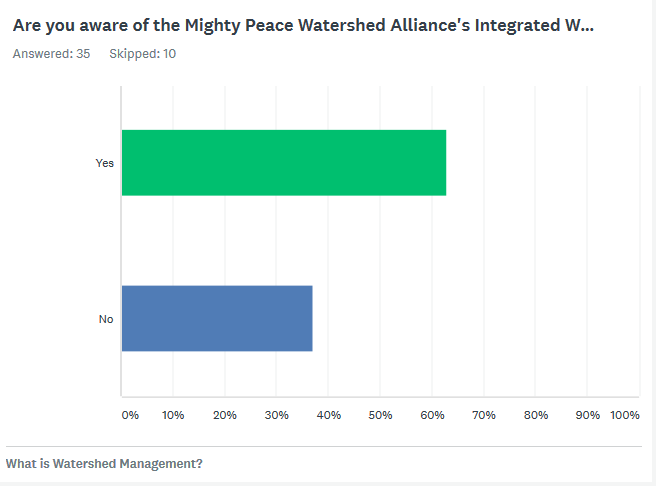
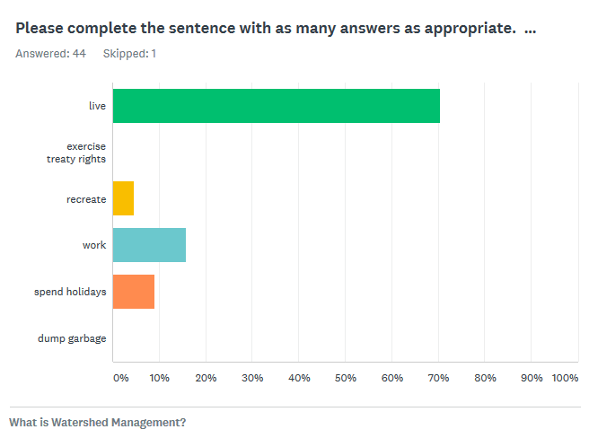
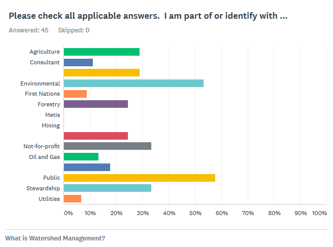
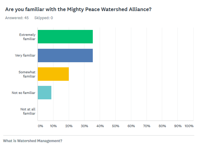
Watershed Management - Let's talk!
Here are some of the places that we were out talking about our water resources:
- Canadian Association of Petroleum Producers Water Policy Group – March 27, 2017
- Alberta Environment and Parks staff – January 30, 2017
- Bigstone Cree Nation and MD of Opportunity – January 25, 2017 in Wabasca
- Water North Coaltion – January 19, 2017 in Valleyview
- North Peace Tribal Council – January 12, 2017 in Fort Vermilion
- Wapiti Area Synergy Partnership – December 13, 2016 7-9 pm at Helen E. Taylor School in Wembley
Keep in touch:
- Google group: https://groups.google.com/forum/#!forum/wapitiasp
- Facebook: https://www.facebook.com/Wapitiasp/
Working Groups are Working
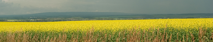
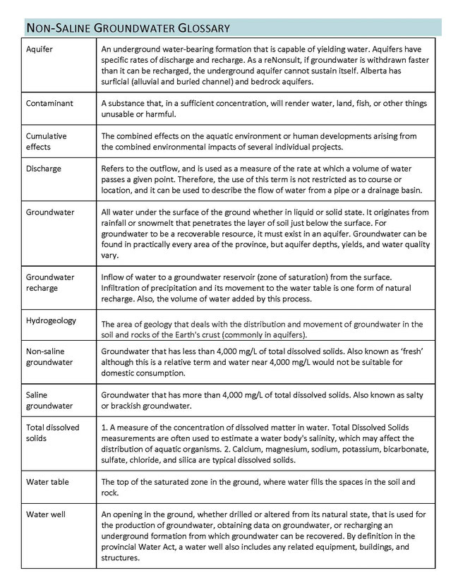
Non-saline Groundwater
MPWA is interested in better understanding our groundwater resources and fostering proactive management. This working group is exploring our non-saline groundwater (fresh water in the ground) resources. Understanding these resources is the first step to identifying needs, risks and potential solutions.
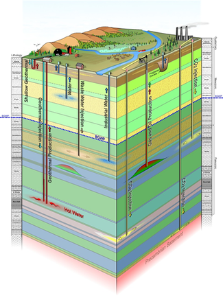
Graphic credit: Alberta Geological Survey
Peace River Flow Regime
The MPWA is looking at Peace River Flow Regime to assess management options to enhance the flood dynamics of the Peace-Athabasca Delta and Lower Peace Wetlands that are flood dependent. Positive and negative implications for the upstream portions are to be considered in relation to any proposed changes in flow regime, including effects on ice bridges.
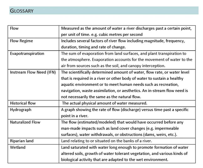
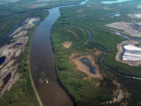
Photo credit: pademp.com
Bow River Phosphorus Management Plan
This video provides an overview of the Bow River Phosphorus Management Plan. It gives a sense of the components that go into a multi-stakeholder watershed management like the Integrated Watershed Management Plan that we are working on for the Peace and Slave Watersheds.
Integrated Watershed Management Plan Discussion Paper
We are starting to flesh out how to move forward on 2 identified Issues of Concern. The Board of Directors is working through recommendations from 2 working groups: 1) Water Quality, Availability and Consumptive Use and 2) Wetlands and Wetlands loss. As part of the process to refine the recommendations from the working groups the Board has produced a discussion paper. This is not an exhaustive examination of topic, but just a sampler to get the converstation going so that we can have discussions with those through the watershed. So please take a look and let us know what you think.
Survey:
Biophysical Context of the Plan
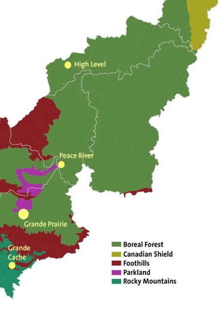
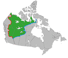
Today, the land cover of the Peace and Slave watersheds is often described using the National Ecological Framework, which combines climate, landforms, soils and plants. Areas that contain similar associations of these components are grouped in progressively more detailed categories. The broadest is the Natural Region, which is sufficient to provide an overview of the character of the Peace and Slave watershed.
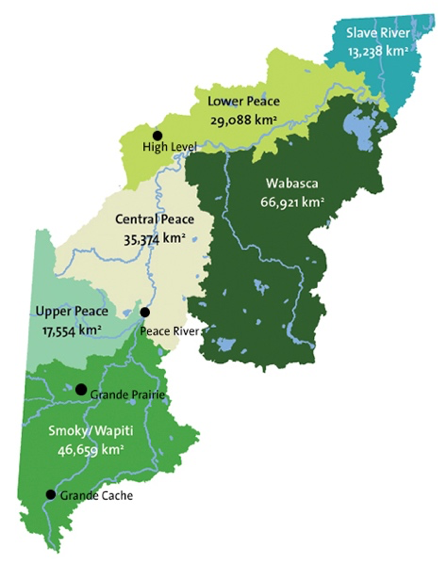
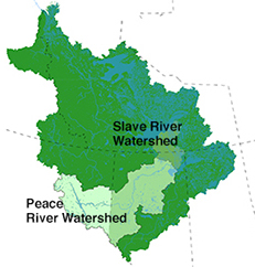
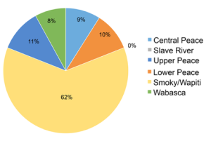
The watershed can also be divided into basins, or sub-watersheds: These include three sub-basins that make up the mainstem of the river (Upper, Central and Lower Peace), two for its major tributaries (Smoky-Wapiti and Wabasca rivers) and one for that portion of the Slave River that is in Alberta.
Stakeholder Engagement
Stakeholder engagement is integral to the development of the Plan and is an opportunity for the MPWA to explain the importance and direction of this work. Equally important is the opportunity for stakeholders to provide input and comment on the IWMP.
- Association of Alberta Forest Management Professionals – April 4, 2016
- Mackenzie Municipal Services Agency – August 26, 2016
- Northern Alberta Elected Leaders – October 14, 2016
- High Level Forests Public Advisory Committee – November 29, 2016
Land Cover
The main stem of the Peace River is about 1,923 kilometres in length. The river stretches from the head of the Finlay River, in the Rocky Mountains of British Columbia, to where it meets the Slave River in northeastern Alberta. In turn, the Peace River watershed is a sub-basin of the larger Mackenzie Basin. The Slave River flows from the Peace-Athabasca Delta in Alberta into the North West Territories where it empties the flows of the Peace River, Athabasca River and Lake Athabasca into Great Slave Lake.
Socio-economic Context of the Plan
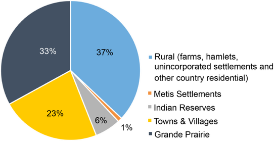
According to the 2011 census, some 165,000 people live in the Peace and Slave watershed. Grande Prairie, with a population of slightly more than 55,000, is the only city in the watershed and ranks as one of the fastest-growing in the province. Towns, villages, hamlets, Indian Reserves and Métis Settlements are scattered throughout the watershed.
Another 23% of the population lived in a town or village. About 6% of the population lived on an Indian reserve. The remainder (37%) lived in rural parts of the watershed.
Policy and Legislative Context
The most relevant piece of policy for this Integrated Water Management Plan is the Water for Life strategy. There are a plethora of other plans, initiatives, policy, guidelines and legislation (see Appendix A) that are relevant in this watershed and as such will be considered by this plan. A few of the most relevant plans, strategies and legislation are the following:
- Water Act (R.S.A. 2000, c. W-3)
- Water for Life
- Land Use Framework
- Mackenzie River Basin Transboundary Waters Master Agreement
- Mackenzie River Basin Bilateral Water Management Agreement
- Canada National Parks Act (S.C. 2000, c. 32)
- Mackenzie River Basin Transboundary Waters Master Agreement
- Mackenzie River Basin Bilateral Water Management Agreement
- Canada National Parks Act (S.C. 2000, c. 32)
Vision, Purposes and Objectives
Vision
The Integrated Watershed Management Plan of the Peace and Slave Watersheds balances and supports our social, environmental and economic objectives.
Purposes
The purpose of this plan is to address effective and sustainable management and use of the water resources. It will also address the maintenance of other benefits provided by the ecological functioning of the watershed. Ensuring that cumulative effects are understood and communicated among all users of the watershed is necessary to improve decision-making about human activity in the watershed. Creation and implementation of this plan will support the achievement of Water for Life’s three main goals of: safe, secure drinking water; healthy aquatic ecosystems; and reliable, quality water supplies for a sustainable economy.
Objectives
In the Integrated Plan, objectives refer to concrete recommendations for policy and planning related to the watershed issues of concern. These recommendations will be developed through a consensus process and draw on the sector(s) directly involved, as well as input from a broad cross-section of those who live, play and work in the Peace and Slave watersheds. Policy and planning recommendations will be supported by the development of an implementation strategy. This implementation strategy will be the roadmap for garnering support and encouraging decision-makers to implement the objectives of this plan.
Management
The Mighty Peace Watershed Alliance Board of Directors will be responsible for and guide the process of the Plan. The Board can delegate responsibilities or duties to committees or consultants. Nevertheless, the final responsibility for the Plan lies with the Board of Directors. The board consists of all directors in good standing at the time. Consultants may be engaged by the board of directors as required. All consultants will be engaged through a Request for Proposals process and then vetted. Staff will support the Board of Directors in the creation of the Plan and fulfill those tasks assigned to them by the board or committees. All reporting eventually goes to the MPWA Board of Directors as they have responsibility for this project. Committees report directly to the Board at all Board meetings and between meetings as required.
Public Input
To help validate the relevance and ensure the utility of this Integrated Watershed Management Plan, public participation will be achieved by means of 5 primary approaches:
- Education and Awareness – this is a general push to make those in the watershed aware of the watershed, our shared uses of it, the need for a management plan and opportunities for input.
- Guided review and discussion
- Open forum – opportunities for questions and non-directed discussion
- Social media – to engage all possible residents in a digital fashion using platforms such as Twitter and Facebook
- Aboriginal community engagement – will be asked how they would like to participate.
Several workshops will be held to identify issues, put forth solutions and consider implementation. Workshops may be held either with a geographical focus in the watershed or specific to a sector.
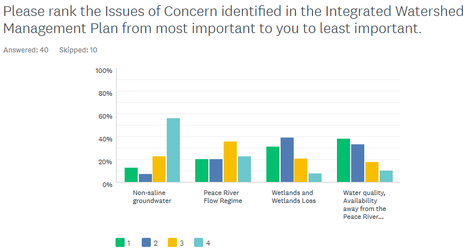
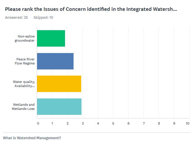
Issues of Concern
Non-saline ground water
The quantity and the quality of non-saline groundwater for human consumption and other uses
Water quality and availability away from the mainstem
Sustainability of reliable drinking water sources for small communities along the tributaries and the functioning of aquatic ecosystems.
Wetlands and wetland loss
The level of understanding of the role and values of wetlands in the watershed
Peace River flow regime
The Peace River Flow Regime and hydrograph
Consumptive use of fresh water (ground & surface water)
Industrial use of water in the context of human consumption needs and aquatic ecosystem health
Evaluation and Approval
This Plan will follow the guidelines laid out in the Guide to Watershed Management Planning in Alberta (2015) and where applicable the Guide to Water Management Planning in Alberta. This will ensure the greatest possibility of the Plan’s approval by the Director and increase its reach. The Terms of Reference will be submitted to the Director.
Consistent with adaptive management principles, the Plan will be regularly reviewed on a 10-year cycle. The Plan will be assessed for effectiveness and relevance and the results of this assessment will guide any necessary revisions. Integral to effective planning is appropriate, relevant and current information; as such the State of the Watershed will also be renewed regularly. The end of the planning cycle is 10 years.
The Goal
The success of the Plan can be measured by several performance indicators. One performance indicator is the approval of this Integrated Watershed Management Plan by the Director. Another performance indicator is the recognized support for the Plan from all the stakeholders identified by the working groups. The number of recommendations that are adopted is also a performance indicator. A final means of evaluating the success of this planning process will to be review the plans using the indicators identified in the State of the Watershed Report. Several approaches available to do this are listed at right.
- Statistically significant – have the indicators changed in a way that is statistically significant (this is the most rigorous approach)?
- Biologically significant – are there changes in the indicator (e.g., fish community) that are noticeable but not statistically significant?
- Environmentally significant – has there been a change in the environment that affects the indicator (e.g.., an improvement in dissolved oxygen for fish communities)?
- Socially significant – are there changes in the societal values and their availability to those in the watershed (maybe there is no counts of increased visits to a lake but anecdotally people are going there more)?
- Economically significant – is there a change to the economic costs of implementation (is the Plan providing cost-effective ways of improving and maintaining watershed function)?